In Yard Editor, select  (the Set Reference Point tool).
Follow these instructions to set the reference points in your placeholder yard.
Before you begin:
You must have completed these previous steps in sequence:
Set up a basic N4 topology
Create a placeholder yard model (on page 1)
Add Bin Name Tables and Bin Names to the placeholder yard model (on page 1)
Create and upload the placeholder image map (replacement topic) (on page 1)
To set reference points:
In Yard Editor, select (the Set Reference Point tool).
On the yard map, click the top left corner of the perimeter. N4 places a little red target on the map and opens the Reference Point form.
In the Reference Point form, in the Longitude and Latitude fields, enter these coordinates:
Longitude: -122.32241
Latitude: 37.80636
When you place the reference point on the map, N4 automatically assigns x-axis and y-axis values to it.
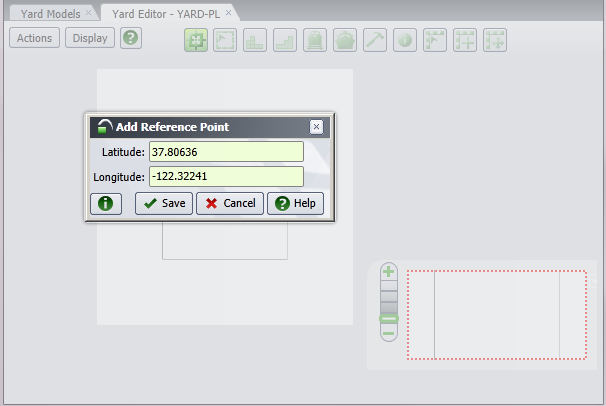
Click Save. The Reference Point form closes.
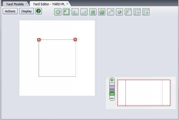
Select the reference point tool again.
On the yard map, click the top right corner of the perimeter. N4 again places a little red target on the map and opens the Reference Point form.
In the Reference Point form, in the Longitude and Latitude fields, enter these coordinates:
Longitude: -122.31586
Latitude: 37.80626
Click Save. The Reference Point form closes. The reference point tool disappears, and N4 displays  (the Yard Perimeter tool).
If you make a mistake adding a reference point, you must delete both reference points and add them again. Select Actions  Delete Reference Points, and click Yes in the Delete Reference Points form. N4 deletes the reference points from the map and hides all drawn yard elements. In addition, the toolbar changes to only display the reference point tool.
Next step(s):
Draw the yard perimeter (on page 1)